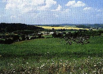
Elevated regions occupy a major part of Belarus. The Polacak lowlands divide the Belarusian uplands into the Western and North-Eastern parts. The highest point is Lysaja Hara (356 m). Belarusian highlands can be of two main forms: elevations with flat surfaces or hilly, mountain-like surfaces. The most hilly are the Navahradak and Vitsebsk regions.
In the center of Belarus, the Navahradak and Minsk elevations rise, the western part being more elevated. From the south, Paliessie intrudes into the area along the rivers Ptych and Biarezina. The rivers flow through wide valleys covered with hay-fields. The main feature of the landscape are stones which are scattered here in great quantities. Lakes are not often encountered in the area. The tops of elevations are extensively covered with fir and mixed forests. The area is highly developed agriculturally due to its damp clay soils. As the country approaches the Biarezina river its soils become poorer. Consequently, that part is not developed and covered with forest. In the South, the country gradually turns into Paliessie.
The Minsk highlands are the highest part of the watershed on the Eastern-European plain. Many small rivers originate on the elevation and flow in all directions from there. Further on, these rivers become big and waterlogged. The Nioman, the Viallja (Vilija), the Biarezina, the Ptych originate on the elevation.
The Navahradak elevation is very rough, and it has a mountain-like appearance. The highest part of the Navahradak elevation is Zamkavaja Gara. In the Slonim region the elevation creates very beautiful landscape called “Slonim Switzerland.” Further to the south the area turns into Paliessie lowlands. In the west Navahradak’s hilly country is followed by the wide sandy valley of the Schara river. Further to the west the Vaukavysk and Hrodna uplands lie. Where the hilly country descends, Belaviezhskaja Puscha - one of the biggest reserves of primeval forests in Europe - is located.
A Navahradak landscape

Northern Belarus, the Dzvina drainage basin, is covered with hills of pure morainic
origin. Two main ridges can be distinguished there: Dzvina’s and Vitsebsk-Nieviel’s. The Dzvina uplands lie north of the
Polacak lowlands. Groups of
hills are mixed with big lakes and sandy Paliessie-like areas. Landscape views change here
very often. The Western Dzvina river flows through the upland. A lot of stones are
scattered both in the river bed and on its banks. East of the Polacak lowland the
Vitsebsk-Nieviel ridges stretch. Here as in the previous case, a lot of stones are
scattered across the region’s hills and gullies. Many lakes can be found in the area.
The most remarkable upland of Eastern Belarus is the Dnieper upland. Beginning in the Upper Dzvina river the upland stretches till the Dzisna river. The Dnieper river flows through the upland. In a south-east direction the Dnieper upland gradually descends into Radanskaja plain. Further to the south the sandy and marshy Paliessie begins. North-west of the upland its steep hills abruptly turn into a big sandy plain. The Dnieper upland’s surface represents a rough country covered with fir forests. The rolling hills have gentle slopes. Rivers create deep valleys embellishing the upland’s beautiful landscapes.
